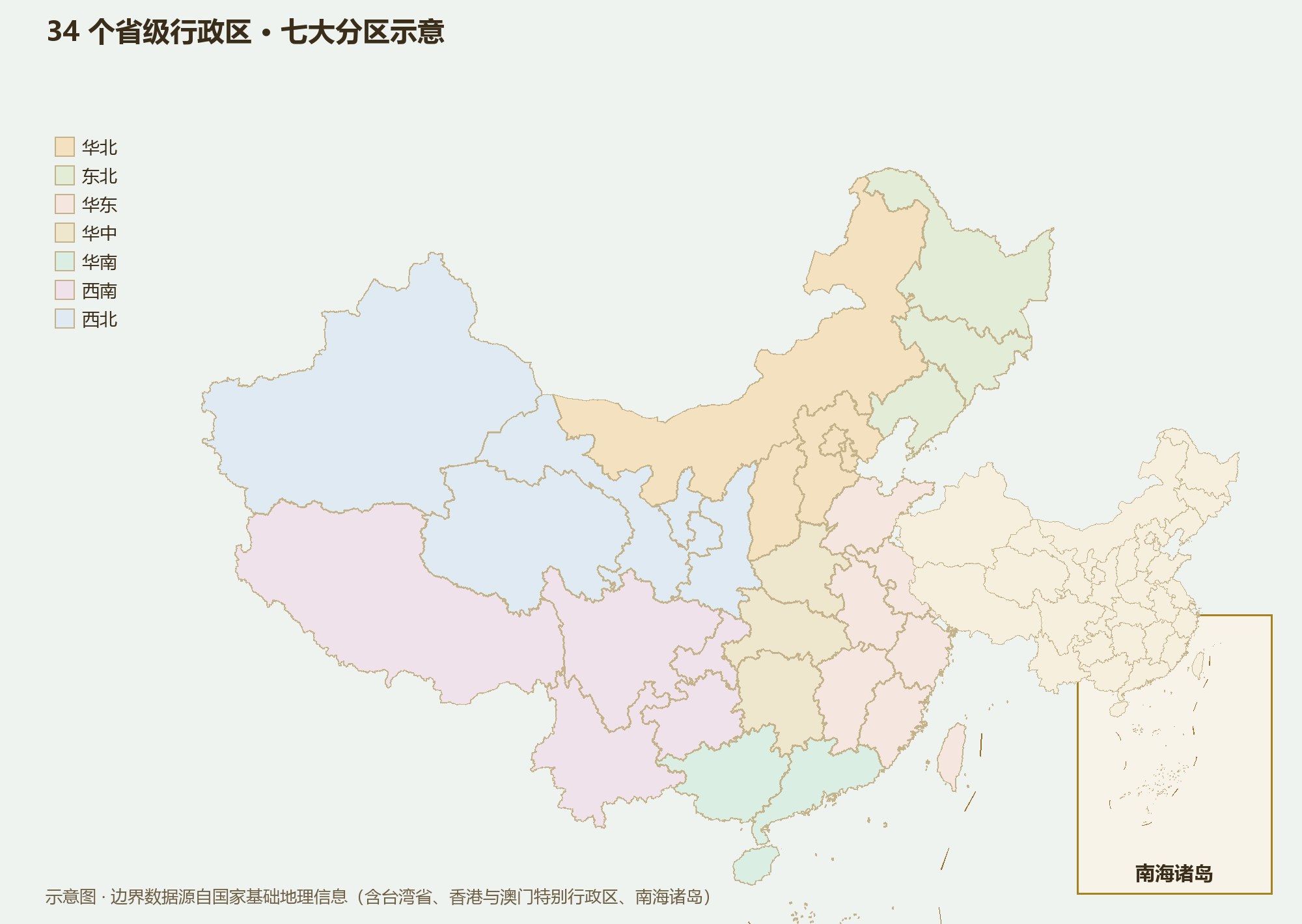
23 provinces, 5 autonomous regions, 4 municipalities, 2 special administrative regions. Don’t memorize the list — learn the categories and the shapes: 34 province cards in seven regional groups.
The “province” is not ancient. The Yuan dynasty created the Branch Secretariat system, dividing the country into ten great districts; the Ming and Qing adapted it, and today’s provinces descend from that reform. The trick to remembering China’s 34 province-level regions is not memorization: sort them into four categories, then seven regions, then remember the shapes.
The 34 province-level regions fall into four kinds: 23 provinces; 5 autonomous regions (Inner Mongolia, Guangxi, Tibet, Ningxia, Xinjiang — the ethnic regional autonomy system); 4 municipalities directly under the central government (Beijing, Shanghai, Tianjin, Chongqing); and 2 special administrative regions (Hong Kong and Macao — “one country, two systems”). Hold the categories and the list grows a skeleton.
The system has a thousand-year pedigree: commanderies under the Qin, provinces and commanderies under the Han, circuits under the Tang, routes under the Song, branches under the Yuan, provincial administrations under the Ming and Qing. Inside today’s provincial borders lies the sediment of all of them — Shanxi’s boundary has barely moved in two thousand years, because mountains drew it.
The three northeastern provinces (Heilongjiang, Jilin, Liaoning) are forest, snow and old industry. North China (Beijing–Tianjin–Hebei, Shanxi, Inner Mongolia) pairs political power with plateau. East China (Shanghai, Jiangsu, Zhejiang, Anhui, Fujian, Jiangxi, Shandong, Taiwan) is the densest coastal economy. Central China (Henan, Hubei, Hunan) is the interior’s crossroads. South China (Guangdong, Guangxi, Hainan, Hong Kong, Macao) faces the South China Sea. The Southwest (Sichuan, Chongqing, Yunnan, Guizhou, Tibet) leans on the roof of the world. The Northwest (Shaanxi, Gansu, Qinghai, Ningxia, Xinjiang) is Silk Road and Gobi.
The regions are not arbitrary: every group shares a mountain, a river or a climate. Learn the regions and you have learned which province touches which.
The outlines of the provinces are uncannily figurative: Xinjiang a vast triangle; Inner Mongolia a long belt across the whole north; Gansu a jade ruyi scepter; Shaanxi a kneeling archer figurine; Heilongjiang a swan; Shandong an eagle’s beak dipping into the Bohai; Taiwan a banana leaf.
The shapes are no accident: most provincial borders follow mountains and rivers — “let the terrain decide.” Inner Mongolia runs sideways with the steppe belt; Gansu is stretched thin between the Qilian Mountains and the Loess Plateau. Remember a shape and you have remembered its position among the mountains and waters.
More than three thousand years as a city and eight hundred and seventy as a capital — seat of the Yuan, Ming and Qing dynasties, and today the political and cultural heart of China.
LandmarksForbidden City · Temple of Heaven · Badaling Great Wall · Summer Palace · Zhoukoudian
A port that grew rich on grain transport; nine foreign concessions left it an open-air fair of world architecture. The sea gate of the Beijing–Tianjin corridor.
LandmarksFive Great Avenues · Ancient Culture Street · Mount Pan · Tianjin Eye · Dagu Fort
Encircling the two municipalities, Hebei runs from the Bashang grassland through the Taihang and Yan mountains down to the North China Plain and Bohai Bay — one of the most geographically complete provinces in China.
LandmarksChengde Mountain Resort · Shanhaiguan Pass · Baiyangdian Lake · Saihanba · Longxing Temple at Zhengding
“Mountains and rivers on every side.” Shanxi preserves the largest body of pre-Yuan timber architecture in China — a treasure house of ancient buildings and grotto art.
LandmarksYungang Grottoes · Pingyao Ancient City · Mount Wutai · Yingxian Wooden Pagoda · Hukou Waterfall
A slender plateau stretching 2,400 km from end to end — through the forests of the Greater Khingan and the Hulunbuir grassland to the dunes of the Badain Jaran desert.
LandmarksHulunbuir Grassland · Ejina populus forest · Xiangshawan (Sounding Sand) · Site of Xanadu (Yuan Shangdu)
The Northeast’s gateway to the sea, where the Liaohe plain embraces the peninsula; cradle of China’s state-run industry, with seaside cities and early-Qing heritage side by side.
LandmarksShenyang Imperial Palace · Dalian seaside · Benxi Water Cave · Qianshan · Xingcheng Ancient City
The black-soil granary of the Northeast. Heaven Lake sits in Changbai’s volcanic caldera, and winter brings the famous rime ice of the Songhua River and powder-snow ski fields.
LandmarksChangbai Heaven Lake · Jilin rime ice · Jingyuetan · Manchukuo Palace Museum
The northernmost province: forests of the Greater and Lesser Khingan, the wetlands of the Sanjiang Plain, a capital of ice sculpture, and scenery along the border rivers.
LandmarksHarbin Ice and Snow World · Beiji Village at Mohe · Wudalianchi · Jingpo Lake
A global metropolis and China’s largest port at the Yangtze estuary — ever since it opened to the world, the window through which modern China has been watched.
LandmarksThe Bund · Yu Garden · Zhujiajiao · Chongming Dongtan wetlands
The flattest province in China, webbed with rivers and canals; gardens, ancient capitals and the Grand Canal string together a thousand years of prosperity.
LandmarksSuzhou gardens · Ming Xiaoling and Sun Yat-sen Mausoleum · Slender West Lake · Zhouzhuang · the Grand Canal (Yangzhou section)
From the misty West Lake to the archipelagos of the East China Sea; a highland of the digital economy and private enterprise.
LandmarksWest Lake · Qiandao Lake · Mount Putuo · Yandang Mountain · Wuzhen and Xitang
The Huai River and the Yangtze divide Anhui into three worlds; in the south, villages of white walls and black tiles — home of the Hui merchants and the Four Treasures of the Study.
LandmarksHuangshan (Yellow Mountain) · Xidi and Hongcun · Mount Jiuhua · Tianzhu Mountain · Huizhou Ancient City
In Fujian the mountains crowd the sea. It was the launching point of the ancient Maritime Silk Road, and remains a famed homeland of overseas Chinese — and of tea.
LandmarksWuyi Mountain · Gulangyu · Fujian Tulou earthen dwellings · Quanzhou old town · Mount Taimu
Open only to the Yangtze in the north, the Poyang plain; Jingdezhen’s porcelain kilns have burned for a thousand years, and the White Deer Grotto Academy still stands on Lushan.
LandmarksLushan · Jingdezhen ancient kilns · Sanqingshan · Wuyuan · Tengwang Pavilion
One mountain, one river, one sage: Mount Tai, the mouth of the Yellow River and the home of Confucius — the birthplace of Confucian civilization and a giant of the northern economy.
LandmarksMount Tai · the Three Confucian Sites at Qufu · Qingdao seaside · Penglai Pavilion · Weishan Lake
The heart of the Central Plains: four of China’s eight ancient capitals — Luoyang, Kaifeng, Anyang, Zhengzhou. Half of Chinese history was written on this plain.
LandmarksLongmen Grottoes · Shaolin Temple · Yinxu ruins · Yuntai Mountain · White Horse Temple
“A thousand lakes, the crossroads of nine provinces.” The Yangtze and the Han meet at Wuhan; this is the heartland of Chu culture and the gateway to the Three Gorges.
LandmarksYellow Crane Tower · Wudang Mountain · Shennongjia · Three Gorges Dam · East Lake
A land of fish and rice around Dongting Lake. The Xiang valley has produced talent for centuries — “Of all the talent under Heaven, Chu has the most.”
LandmarksZhangjiajie · Fenghuang Ancient Town · Yueyang Tower · Mount Heng (Nanyue) · Langshan Danxia
China’s most populous province and its largest provincial economy, facing the South China Sea across the Pearl River Delta; the historic frontier of reform and opening, home of Lingnan culture and great overseas-Chinese communities.
LandmarksDanxia Mountain · Kaiping Diaolou towers · Canton Tower · Dinghu Mountain · Hong Kong–Zhuhai–Macao Bridge
A basin embraced by towers of limestone — “Guilin’s scenery is the finest under Heaven.” Facing the Beibu Gulf, Guangxi holds both border passes and a sea frontier.
LandmarksLi River at Guilin · Yangshuo · Detian Waterfall · Beihai Silver Beach · Longji Rice Terraces
China’s largest special economic zone and only tropical island province, administering vast islands and waters of the South China Sea; a free-trade port in the making.
LandmarksTianya Haijiao at Sanya · Wuzhi Mountain · Fenjiezhou Island · Xisha (Paracel) Islands
The largest of the four direct-administered municipalities, a “magical 8D mountain city” built among parallel ridges; the shipping and economic hub of the upper Yangtze.
LandmarksHongya Cave · Dazu Rock Carvings · Wulong Karst · Baidi City · Yangtze River Cableway
The “Land of Abundance” — one basin is a world entire. The western plateau runs from Jiuzhaigou to Daocheng Yading, with some of the densest scenery in China.
LandmarksJiuzhaigou · Daocheng Yading · Mount Emei · Leshan Giant Buddha · Dujiangyan · giant panda habitat
“Not three li of flat land anywhere”: a karst plateau pieced together from waterfalls, caves and gorges, and a cool summer retreat that averages 23°C in July.
LandmarksHuangguoshu Waterfall · Libo Xiaoqikong · Fanjingshan · Xijiang Thousand-Household Miao Village
“South of the Clouds”: from the rainforest of Xishuangbanna to the snow peaks of Meili, one province holds all four seasons — and 26 long-settled ethnic groups, the richest human diversity in China.
LandmarksLijiang Old Town · Jade Dragon Snow Mountain · Stone Forest · Xishuangbanna · Erhai Lake · Meili Snow Mountain
The greater part of the roof of the world, averaging above 4,000 meters: sacred mountains and holy lakes, the heartland of Tibetan Buddhism — the land nearest the sky.
LandmarksPotala Palace · Mount Kailash · Namtso Lake · Mount Qomolangma (Everest) · Jokhang Temple
Loess country, the Guanzhong plain and the Qinling range — a hardbound volume of Chinese history, seat of fourteen dynasties from the Zhou to the Tang.
LandmarksTerracotta Army · Mount Hua · Giant Wild Goose Pagoda · Hukou Waterfall · Xi’an City Wall
Shaped like a jade ruyi scepter: from the loess hills of the east, down the Hexi Corridor, to the deserts of Dunhuang — the golden stretch of the Silk Road.
LandmarksMogao Grottoes at Dunhuang · Mingsha dunes and Crescent Spring · Maijishan Grottoes · Jiayuguan Pass · Zhangye Danxia landform
The source of the Yangtze, the Yellow River and the Lancang (Mekong) — the water tower of China. A province of alpine lakes, snow mountains and high grassland.
LandmarksQinghai Lake · Chaka Salt Lake · Sanjiangyuan source reserve · Ta’er (Kumbum) Monastery · Qilian Mountains
“The Yellow River enriches Ningxia”: irrigation turned this dryland into an oasis south of the steppe. Beneath the Helan Mountains lie the tombs of the Western Xia empire.
LandmarksShapotou · Helan Mountain rock art · Western Xia Imperial Tombs · Zhenbeipu Western Film Studio
China’s largest province-level region: the Altai, Tianshan and Kunlun ranges cradle the Junggar and Tarim basins — glaciers, oases, desert and steppe all in one territory.
LandmarksKanas Lake · Heaven Lake of Tianshan · Sayram Lake · Flaming Mountains · Kashgar Old City · Pamir Plateau
A high mountain island in the western Pacific, stitched north to south by the Central Range. Yushan (3,952 m) is the highest peak in eastern China, and the Tropic of Cancer crosses the center and south.
LandmarksYushan · Sun Moon Lake · Alishan · Taroko Gorge · Kenting
An international financial center where East meets West, a harbor city woven of mountains and sea — shipping, trade and finance gathered in one place.
LandmarksVictoria Peak · Victoria Harbour · Big Buddha at Ngong Ping · Hong Kong Palace Museum
Four centuries as the meeting point of China and the West. The entire Historic Centre is a World Heritage site, where European facades and street-market life coexist.
LandmarksRuins of St. Paul’s · Historic Centre of Macao · A-Ma Temple · Rua do Cunha
Areas are approximate. Population figures follow the Seventh National Census (2020) resident count; Taiwan, Hong Kong and Macao are local published figures (c. 2020–2021). Taiwan Province and the Hong Kong and Macao SARs are listed after East China and South China respectively.