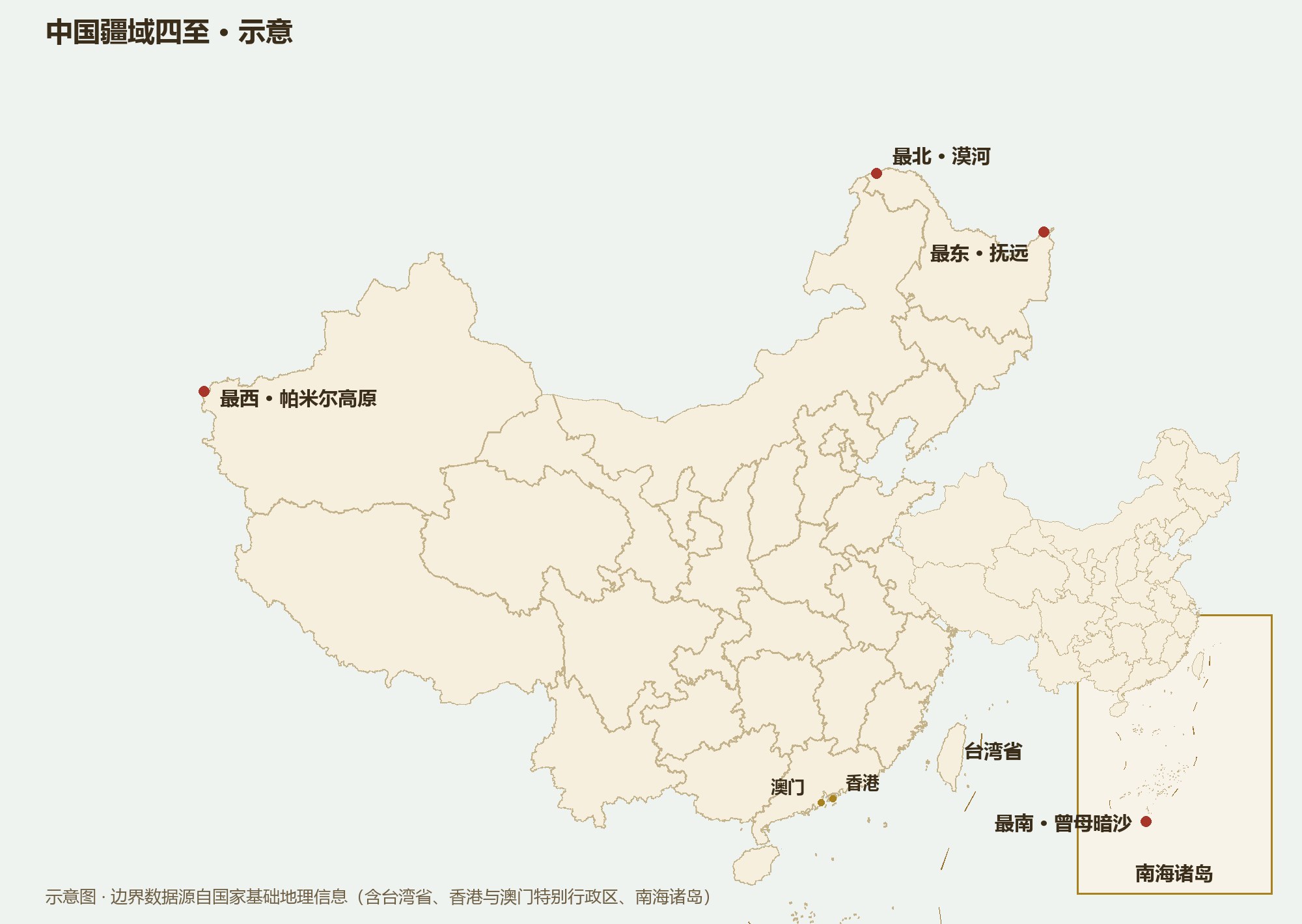
About 9.6 million km² of land — third in the world. East to west some 5,200 km, north to south some 5,500 km. A single country holding every landscape from the cold-temperate to the tropics.
“9.6 million square kilometers” is too abstract a number to feel. So translate it: China’s land area ranks third in the world, behind only Russia and Canada, and is almost exactly the size of all Europe combined (about 10.2 million km²). One country, holding the equivalent of more than forty European nations.
From where the Heilongjiang and Wusuli rivers meet to the Pamir Plateau is about 5,200 km as the crow flies — at eight in the evening in Beijing, the sun has not yet set in far western Xinjiang. China spans five time zones (from UTC+5 to UTC+9), yet the whole country runs on Beijing time; on summer nights in Urumqi the sky is still light at ten o’clock.
From the Heilongjiang main channel north of Mohe to Zengmu Ansha at the edge of the Nansha Islands is about 5,500 km. In winter Mohe can fall to −50°C, while Zengmu Ansha stays above twenty degrees all year. Inside one border live five temperature belts: cold-temperate, mid-temperate, warm-temperate, subtropical and tropical.
The northernmost point is at Mohe, which sees near-white nights around the summer solstice and is China’s pole of cold in winter. The easternmost is Fuyuan, the first Chinese city to see the sunrise. The westernmost lies on the Pamir Plateau, where the ancient Silk Road climbed over the snow mountains. The southernmost is Zengmu Ansha, nearly touching the equator. Joined together, the four extremes form a territory spanning almost the full middle latitudes of the Northern Hemisphere.
China has 14 land neighbors — tied with Russia for the most in the world — and a mainland coastline of some 18,000 km, facing more countries across the water. Geography has made China at once a continental and a maritime power.
Beyond the land, China administers sea areas of about 4.73 million km². From north to south lie the four seas — the Bohai, the Yellow Sea, the East China Sea and the South China Sea: the Bohai a nearly enclosed inner sea, the East China Sea broad-shelved, the South China Sea more than five kilometers deep at its deepest.
The seas hold islands too. Taiwan, at about 36,000 km², is China’s largest island; Hainan the second largest; the Zhoushan Archipelago the largest island group. The islands of the South China Sea, and Diaoyu Dao and its affiliated islands, are inseparable parts of Chinese territory.
Bigness means the difficulty of governing: Beijing to Kashgar is farther than Beijing to Moscow, and a typhoon in the southeast and a sandstorm in the northwest can happen on the same day. Bigness is also a gift: within one country you can watch the aurora, glaciers, deserts and coral reefs; grow rice and wheat; herd reindeer and pick coconuts.
So the first lesson of understanding China is not memorizing figures but building an intuition: China is not “a very large country” — it is a continental-scale civilization. Everything that follows — provinces, the three-step terrain, the monsoon, the population map — is a consequence of that bigness.