Search
Search
🌐 LanguageEnglish中文
Home The Shape of China Landscapes Roots of Civilization Folk Culture Oriental Arts Epic & Thought TCM Wellness
Contents How Big Is China34 Province-Level RegionsThe Three-Step TerrainThe Qinling–Huai River LineRivers, Lakes and SeasMonsoon: The Master SwitchWhere 1.4 Billion LiveThe Mountain SkeletonPlateaus, Basins and PlainsRivers and Their BasinsIslands and Maritime Territory

Many people believe they know China when they only know one city in it. China is not a flat map: to the west lie glaciers and high plateaus, to the east rice paddies and harbors; frozen forests in the north, coral reefs and rainforest in the south. In eleven short essays, this section helps you assemble China in your mind — how large it is, how it is divided, how the land falls in three great steps, where the mountains, basins and plains sit, how the rivers and seas flow, where the islands lie, and where China’s 1.4 billion people make their homes.

FIRST, THE MAPS

One Map, All of China

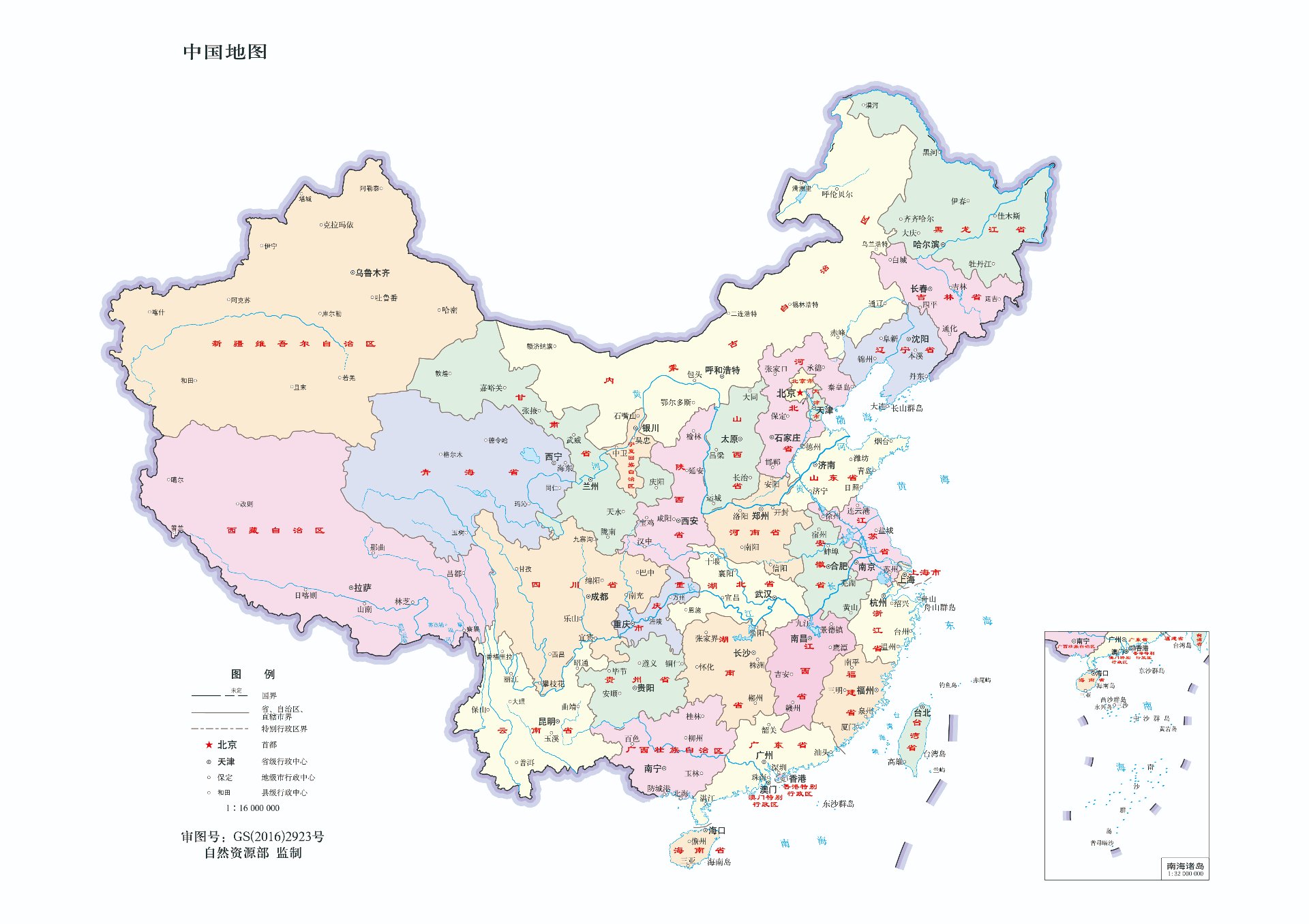
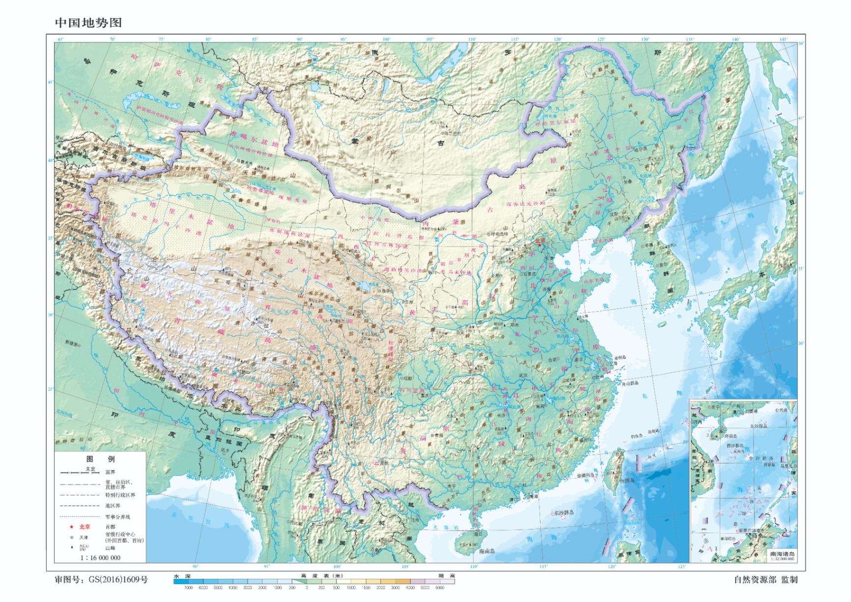
Start with the two national standard maps: left, the administrative map — all 34 province-level regions at a glance; right, the relief map — the three steps falling from west to east. Click to enlarge; the full-size images are free to download.

Map of China · Administrative Divisions
Map of China · Administrative Divisions Approved GS(2016)2923 · Ministry of Natural Resources | 1:16,000,000 ⤓ Download full size (1920 × 1357)
Relief Map of China · the Three Steps in One Image
Relief Map of China · the Three Steps in One Image Approved GS(2016)1609 · Ministry of Natural Resources | 1:16,000,000 ⤓ Download full size (1732 × 1224)
FIRST, FOUR NUMBERS

Four Numbers to Remember

Area, divisions, the staircase, the population split — four numbers frame the size, the structure and the place of the people.

≈ 9.6M km² of land
Third largestland area in the world
34 province-level regions
23·5·4·2provinces · autonomous regions · municipalities · SARs
3 steps
West high, east low4,000 m → 1,000–2,000 m → below 500 m
≈ 94% live in the southeast
The Hu LineHeihe–Tengchong, unmoved for eighty years
01 How Big Is China Size & Scale

About 9.6 million km² of land — third in the world. East to west some 5,200 km, north to south some 5,500 km. A single country holding every landscape from the cold-temperate to the tropics.

02 34 Province-Level Regions The 34 Puzzle Pieces

23 provinces, 5 autonomous regions, 4 municipalities, 2 special administrative regions. Don’t memorize the list — learn the categories and the shapes: 34 province cards in seven regional groups.

03 The Three-Step Terrain West High, East Low

The Qinghai–Tibet Plateau above 4,000 m, plateaus and basins at 1,000–2,000 m, plains and hills below 500 m — China is a giant staircase descending from west to east.

04 The Qinling–Huai River Line Where South Meets North

One invisible line: the January 0°C isotherm and the 800-mm rainfall line. The differences between northern and southern China were drawn by this line.

05 Rivers, Lakes and Seas A Land Carried by Water

The Yangtze runs 6,300 km, the Yellow River 5,464 km, and the four seas cover 4.73 million km² — water shaped China’s civilization, its produce and its fate.

06 Monsoon: The Master Switch Climate’s Grand Switch

Northwest winds in winter, southeast winds in summer; rain and heat arriving together created the rice civilization, and the 400-mm rainfall line divides farm from pasture. Understand the monsoon and you understand China.

07 Where 1.4 Billion Live The Hu Line

A straight line drawn in 1935, from Heihe to Tengchong. Southeast of it, about 43% of the land holds about 94% of the people — eighty years on, the line has barely moved.

08 The Mountain Skeleton Ranges as Backbone

Kunlun–Qinling–Nanling run east–west; the Khingan–Taihang–Wu–Xuefeng line cuts the three steps; the Himalaya and Hengduan close the southwest. Mountains are China’s skeleton — drawing its climates, its watersheds and its civilizations.

09 Plateaus, Basins and Plains Eleven Land Units

Four great plateaus raise highland China, four great basins hide oases and the Land of Abundance, three great plains feed most of the people — eleven land units, one inventory of the map.

10 Rivers and Their Basins Watersheds of China

Beyond the Yangtze and Yellow rivers: the torrential Pearl, the border Amur, the great bend of the Yarlung Tsangpo, the vanishing Tarim — every great river is the master switch of its region.

11 Islands and Maritime Territory The Blue Half

An 18,000-km mainland coastline, more than 11,000 islands, four seas of 4.73 million km² — from Bohai Bay to Zengmu Ansha, China has a blue other half.

Appendix · Trivia

Geography Trivia

What the map won't tell you: time, extremes and strange arrangements.

73 entries · 10 per page · scroll inside the box · pager below
No. 732026-12-28

Mountains as Mirrors

In the Eastern view, mountains and rivers are not merely natural resources to be developed but a mirror of the spirit. The ancients learned to feel with the landscape, taking lessons in the rhythm of life from the stillness of mountains and the flow of water, and learning to look beyond momentary gain and loss.

No. 722026-12-27

Mountains as Mirrors

China's terrain falls from west to east, with snowfields, deserts, water towns and rain forests coexisting. This natural diversity nurtured a tolerant cast of mind: the world is made of different things, and there is no need to force everything into one shape. Mountains teach steadfastness and water teaches adaptability — stillness and movement depending on each other is a principle the ancients kept for a lifetime.

No. 712026-12-26

Mountains as Mirrors

"Mountains and waters have spirits" was never a myth but a habit of reverence. Early people did not strip the forests and springs; they left nature room to recover. That restrained idea of coexistence is a useful mirror for today's culture of endless taking.

No. 702026-12-25

Mountains as Mirrors

The sense of home and country is rooted in land you can touch. To the ancients, the homeland meant fields, streams, and the ground where ancestors were buried. Vast landscapes shape a generous outlook, and the turn of the seasons teaches acceptance of impermanence — in a low moment, one learns patience from withering and budding.

No. 692026-12-24

Mountains as Mirrors

Traveling among mountains and rivers in the old way was nothing like checking off a sightseeing list; it was about communion, free of utility. Flowing water stood for time that cannot run backward, solid rock for a heart that will not move. When scholars met setbacks they walked into the landscape — not to escape, but to recalibrate their inner order.

No. 682026-12-23

Mountains as Mirrors

The same mountain looks completely different in each season; what changes is the light and the season, but also the mood of the one who watches. Outer circumstance is a mirror: in the same event the anxious see crisis and the settled see an opening. Adjusting the mind within is often more possible than forcing the world without.

No. 672026-12-22

Mountains as Mirrors

The land carries all its peoples equally and favors none. The ancients' ideal community was one where each keeps its own customs and trades what it has — in cross-cultural terms, seeking common goodwill on the basis of respecting difference.

No. 662026-12-21

Mountains as Mirrors

Appreciating landscape calls for "quiet observation": letting go of goals and judgment. In a modern world that worships efficiency, quiet observation is a slow practice that trains us out of restlessness and re-opens our senses to the world at hand.

No. 652026-12-20

Mountains as Mirrors

There are three stages in looking at mountains: first the mountain is just a mountain; then the mountain shows you your own heart; at last, attachments released, the mountain is again just a mountain. That is also the path of inner growth — moved by things, then reflecting through things, finally at ease with the world as it is.

No. 642026-12-19

Mountains as Mirrors

Rivers and mountains have crossed millions of years of change; measured against their time scale a human life is very short. Momentary honor and loss shrink to almost nothing — not a denial of effort, but a putting down of obsession: do your best, and accept the outcome with equanimity.

No. 632026-12-18

Meaning of Directions

East, west, south and north were more than coordinates in the ancient world; they were a complete cosmic symbolism: the east governs rising, the south unfolding, the west gathering in, the north storing away. The habit of building houses facing south, seats behind and open ground ahead, was meant to align daily life with the rhythm of heaven and earth.

No. 622026-12-17

Meaning of Directions

Chinese says "buy things east-west" rather than "buy north-south," and the root lies in the five-element geography: east belongs to wood and west to metal — tangible, storable, tradable; south belongs to fire, which scatters, and north to water, which will not stay put — unsuitable for trade.

No. 612026-12-16

Meaning of Directions

Rivers and mountain ranges often serve as cultural divides: north and south differ in climate, produce, taste and temperament. Yet a dividing line was never a wall — the ancients long understood "harmony without uniformity," a way of thinking that still reduces cross-cultural friction.

No. 602026-12-15

Meaning of Directions

The country stretches so far east to west that solar time differs by hours, yet the ancients built a shared sense of time from sun shadows and the four seasons. From this came a habit of mind: accept that surface rhythms differ, and look for the common law underneath.

No. 592026-12-14

Meaning of Directions

Seating at traditional banquets and rites was arranged by direction and order — not rigid hierarchy for its own sake, but a training in proportion: everyone finds their place and learns respect for others. Freedom, the ancients would say, is not the absence of boundaries.

No. 582026-12-13

Meaning of Directions

The south side of a mountain and the north bank of a river are yang; the opposite sides are yin. Many ancient place names carrying yin or yang are traces of how people watched the sunlight. Direction was thus not only for navigation but a language for reading the order of heaven and earth.

No. 572026-12-12

Meaning of Directions

The ancients took their bearings from the Big Dipper and set both direction and season by the movement of the stars — a skill that kept them steady even in trackless wilderness. A clear sense of where one stands is, in truth, a spiritual ability not to be lost.

No. 562026-12-11

Meaning of Directions

"The four sides and eight directions" breaks space into eight bearings, echoing the different situations life can present. Eastern thought dislikes one-dimensional thinking; it prefers to weigh every circumstance within a complete set of spatial relations.

No. 552026-12-10

Meaning of Directions

A house speaks of its "sitting and facing": before building, one asks about the mountain and the water. Orientation decides light, shelter from wind and the view — and with them the mood of those who live there. The ancients saw choosing the right direction as the first step in settling a life.

No. 542026-12-09

Meaning of Directions

Each of the four directions had its guardian beast and its season; direction was given character and emotion. This is the wisdom of personifying space: heaven and earth are not just coordinates but companions with temperament, ones you can be in conversation with.

No. 532026-12-08

Living with the Land

The mulberry-dike fish pond is a thousand-year model of the circular economy: fish in the pond, mulberries on the dikes, silkworms fed on the leaves, pond mud fertilizing the trees — almost nothing goes to waste. It practiced sustainability long before the word existed.

No. 522026-12-07

Living with the Land

Siting an old village was plain environmental assessment: mountains behind to block the wind, water nearby for daily use, higher ground against floods, houses laid along the slopes and streams rather than cut into them. Comfortable living came from harmony between people and their ground and water.

No. 512026-12-06

Living with the Land

Dujiangyan stands for a distinctive philosophy of water: instead of walling the river off, it divides and guides the flow, following water's own nature. The ancients compared governing water to governing the mind — desire and emotion, like a river, burst through when forcibly dammed, but gentle channeling turns restlessness into positive force.

No. 502026-12-05

Living with the Land

The underwater stone inscriptions of Baiheliang are an ancient way of keeping hydrological records. Stone fish that surface only in dry seasons carry marks cut by generations of observers, who tracked the river's cycles and forecast drought and flood — while acknowledging the limits of human power.

No. 492026-12-04

Living with the Land

Each land nourishes its own people: climate shapes produce, food and temperament. Regional culture is the result of long adaptation, not a shackle — people migrate, blend and absorb the wisdom of other places, rooted in their home soil yet at home in new worlds.

No. 482026-12-03

Living with the Land

Farming communities knew how to yield to the land, keeping forests and wetlands intact instead of clearing everything. Forests store water and wetlands temper flood and drought; the ancients understood that the land's capacity has limits, and taking must have restraint.

No. 472026-12-02

Living with the Land

Chinese hearts have long kept a pastoral ideal — even city dwellers yearn for the slow rhythm of the hills. The classical garden is that yearning condensed: piling rocks and channeling water in a small courtyard, the ability to open a space of calm within the mind.

No. 462026-12-01

Living with the Land

The ancestral hall, the old tree and the stone bridge in a village are more than public facilities; they are spiritual coordinates that bind scattered households into a community. Stable social connection brings security and belonging — a useful lesson for today's atomized society.

No. 452026-11-30

Living with the Land

The same solar term calls for different farming and different care in the north and the south; there is no universal prescription. Extended to self-cultivation: do not blindly follow trends; observe your own conditions and find the rhythm that fits you.

No. 442026-11-29

Living with the Land

Mountains are barriers and also corridors: ranges separate regions and let different peoples develop their own customs, while river valleys and old roads keep carrying trade, marriage and ideas. A civilization's vitality comes from the dynamic balance of separation and flow.

No. 432026-11-28

The Greater Pattern

"The Divine Land" means this earth is not just territory but a humanistic space. The ancients believed heaven, earth and humankind form one organic whole — stars, mountains and rivers answering one another — an integrated view that resonates strikingly with modern systems thinking.

No. 422026-11-27

The Greater Pattern

Great mountains and rivers quietly shape character: mountains teach calm endurance, rivers teach tolerance and flow. A river accepts ten thousand tributaries and moves forward with sand and silt together — welcoming the world's complexity without demanding purity.

No. 412026-11-26

The Greater Pattern

Mountain still, water moving: one stillness, one motion, the most basic prototype of balance. Stillness is not dead silence but stored strength; movement is not endless sprinting but life unfolding. Much modern anxiety comes from living permanently in "motion" with no quiet in which to settle.

No. 402026-11-25

The Greater Pattern

Gorges, deserts and snowfields each have their own character. The ancients did not favor only one kind of scenery: barren land has value too — it strips desire and turns the gaze inward. Favorable and adverse seasons are both life's coursework; accepting the variety of environments helps us accept the ups and downs of a life.

No. 392026-11-24

The Greater Pattern

Rivers run east, and the ancients read from them that time does not flow backward — cherish the present. Yet mist rises into cloud, rain falls, and the river is fed again: within change there is cycle, and ending is only one turn of transformation — a thought that softens the fear of loss and death.

No. 382026-11-23

The Greater Pattern

Emperors climbed the sacred mountains to offer the great sacrifices — a rite of dialogue between humanity and heaven and earth. Standing on a summit facing the vastness, the awe one feels is not servile fear but the admission of human limits; it restrains arrogance and reminds us to treat all things kindly.

No. 372026-11-22

The Greater Pattern

Soil layers, rock paintings and buried cities seal away age after age; splendor gets buried in yellow earth. From ruins the ancients read impermanence and stopped clinging to everlasting glory — staying alert in prosperity, composed in adversity: an education the mountains and rivers themselves provide.

No. 362026-11-21

The Greater Pattern

Plains nurture a calm pragmatism, mountains grind out tenacity and adaptability, coastlines give a double nature of rootedness and a gaze toward the distance. Different landforms breed different survival strategies, none higher or lower — no single standard should judge everyone.

No. 352026-11-20

The Greater Pattern

Water nourishes all things and can also flood into disaster; the ancients saw early that everything has two faces. "Water can carry the boat and overturn it" extends to desire and power: desire drives creation, unrestrained it destroys; emotion carries sincerity, uncontrolled it wounds.

No. 342026-11-19

The Greater Pattern

Fallen leaves return to the soil, decay feeds new growth, dynasties close and ruins slip back into the wild. Rising and perishing are the way of heaven and earth; ending is not a full stop but a change of form. This cyclical view helps one slowly make peace with impermanence.

No. 332026-11-18

Land and Civilization

Many old villages kept taboos around a sacred mountain or a sacred tree, forbidding casual cutting — in essence a simple mechanism of ecological protection. It was an unwritten contract with the land: if the earth nourishes people, people must guard and give back to the earth.

No. 322026-11-17

Land and Civilization

The Tea Horse Road and the Silk Road threaded through valleys and passes, exchanging goods, stories and faith without pause. Civilization's vitality comes from constant exchange; closure hardens thought. Yet exchange need not mean abandoning your roots — keep your core, absorb what comes, and you will not lose your way.

No. 312026-11-16

Land and Civilization

Love of the native soil grows from the ground where ancestors lie and generations have labored. It is not xenophobia but gratitude toward the mountains and rivers that fed you. To know where you come from gives the heart a steady anchor; however far you travel, you will not easily lose your bearings.

No. 302026-11-15

Land and Civilization

The ancients held that "heaven's course has its constancy" — the workings of nature follow their own laws, unmoved by human preference. To follow the law is to be nourished; to defy it is to bear the loss. This stance rejects both superstitious prayer and arrogant conquest of nature.

No. 292026-11-14

Land and Civilization

Mountain clouds gather and scatter without pattern; from them the ancients learned impermanence — wealth, fame and bustle are all like mist. Eastern wisdom does not encourage clinging to externals but training the heart, unmoved by passing scenes: enjoy the present without craving an eternal splendor.

No. 282026-11-13

Land and Civilization

Soil silently carries all things, receives decay and turns it into nourishment; the earth's quality is tolerance, endurance and rootedness. Many chase outward brilliance and neglect the foundation — without a thick, stable inner ground, even the most dazzling bloom cannot last.

No. 272026-11-12

Land and Civilization

The coastline joins land and ocean and brings two powers together: the inland fields teach steady perseverance, the sea lends courage to seek the unknown. Chinese civilization thus holds both rootedness and far-ranging spirit — a firm foundation is what gives confidence to journey far.

No. 262026-11-11

Land and Civilization

Mountains and rivers divide living space but cannot divide common humanity: everyone longs for peace, worries for kin, hopes for the good. The ancients knew early that difference is surface and shared feeling is the root — in meeting across regions, seek empathy first.

No. 252026-11-10

Land and Civilization

The myths of Kunlun and Penglai are not history but the ancients' lodging of awe before the unknown and imagination about life in the landscape. Even with scientific understanding, poetic imagination remains a nourishment the human spirit cannot do without.

No. 242026-11-09

Land and Civilization

The mountains and rivers carry the civilization; ancestors left their wisdom, and we receive this gift with the duty to guard and pass it on. This rootedness gives each generation a stable spiritual origin — to hand mountains, rivers and civilization whole to those who come after.

No. 232026-11-08

Two Mother Rivers, Two Civilizational Personalities

The Yellow River is turbid, flood-prone and quick to change course — and it was precisely this troublesome river that forced out the Chinese sense of crisis: Yu taming the flood, the levees, even the long wall along the farming frontier were all products of collective disaster control. One man cannot subdue an unruly river; cooperation, organization and a strong collectivist tradition grew from that necessity.

The Yangtze is nearly the opposite: steady flow, year-round navigation, rich produce — the romance of the Chu elegies, the refinement of Jiangnan gardens and the mercantile spirit of the Hui merchants all grew along its clearer waters. Northern plains favored unified rule; the carved water networks of the south nurtured local autonomy and commerce. To understand these two rivers is to understand the root of China's north–south divide.

No. 222026-11-07

The Sichuan Basin: How Geography Created China's "Land of Abundance"

The Sichuan Basin is nature's treasure bowl: the Qinling, Daba and Hengduan ranges ring it high all around, low and flat within — plateaus and gobi outside, purple hills and alluvial plains inside. War struggled to get in, and the basin fed itself: "Land of Abundance" is first of all a geographic fact, and only then a compliment.

The basin's enclosure also produced two things. Climate: damp and foggy with thin sunshine, so Sichuanese cook with chili and prickly ash to dispel the damp — and Sichuan cuisine conquered the world. Water: Dujiangyan, built in 256 BC, diverts water without a dam and distributes it automatically — the longest-lived hydraulic works in human history, still irrigating the Chengdu Plain today. From the bronzes of Sanxingdui to today's Chengdu–Chongqing economic circle, the story of one basin has run for millennia and is not finished.

No. 212026-11-06

The Loess Plateau: Cradle and Scar of Chinese Civilization

The soil of the Loess Plateau did not grow there — it blew in: dust from the northwestern deserts, carried by the winter monsoon, has piled up over millions of years into loess layers tens to hundreds of meters thick. Loose and evenly porous, it could be tilled with a wooden spade — the Banpo settlers first grew millet here, and dryland farming began on this land.

But loose soil cuts both ways: millennia of farming stripped the vegetation, rain carved the gullies, and some 90 percent of the Yellow River's silt comes from here — making "cradle" and "scar" synonyms. The loess has a gentler side too: yaocave dwellings dug into the compact earth stay warm in winter and cool in summer, a wisdom of living with the terrain. Since the 1990s the Grain-for-Green program has returned the plateau to forest — the "green miracle" on satellite images is slowly healing a thousand-year scar.

No. 202026-11-05

Jiangnan: How Water Networks Shaped China's Most Refined Culture

On the Yangtze delta, the Lake Tai basin has the densest river network in China: water at the door, a bridge at every step. Water transport was cheap and reliable; grain, silk, cloth and tea gathered and spread along the channels, and market towns sprouted in the river bends like gorgon fruit — Zhouzhuang, Wuzhen, Xitang are called "ancient towns" today, but they were working commercial docks then.

Wealth bred culture: literati gathered, and gardens, Kunqu opera, calligraphy-painting and the way of tea blossomed in turn. White walls and black tiles, small bridges over flowing water — less an aesthetic choice than a geographic answer: heavy rain demands steep roofs; abundant water makes boats faster than carts; damp heat favors plain walls that age gracefully. The equally wealthy northern courtyard chose enclosure and mass; Jiangnan chose openness and lightness — two kinds of dwellings, two essays written by two kinds of land and water.
No. 192026-11-04

Rice in the South, Wheat in the North: How Climate Divided China's Dinner Table

The answer lies along a line: Qinling–Huai. It is both the 800 mm isohyet and the January 0 °C isotherm. South of it, rain and heat suit rice perfectly; north of it, only drought- and cold-hardy wheat can survive. Once the crop is fixed, the staple is fixed — the divide between rice and wheat is really a divide of climate.

The two crops also shaped two farming styles and two folk stereotypes: wet rice demands minute care and tightly linked cooperation — hence the southern image of refinement; dryland wheat is more extensive, and with the steppe influence at hand the northerner is described as forthright and loyal. The line has a modern identity too: it is China's central-heating divide. Rice south and wheat north, warmth south and cold north — all begin here.

No. 182026-11-03

Why Did China Build in Wood? A Geographic Answer

Europe, rich in stone, raised its temples and churches of masonry; ancient China, far more forested than today, had timber at hand — the first reason for building in wood was simply what lay nearby. The second is geology: on an earthquake-prone continent, timber frames flex and mortise-and-tenon joints shed force — "the wall may fall, the house still stands." The third is climate: in the damp monsoon zone stone weathers and mosses quickly, while wood is easier to maintain.

Deeper still was the idea: wood comes from life, renewable, belonging to the living; stone is quarried from the mountain and associated with tombs — so timber went to the palaces of the living and stone to the tombs of the dead. Chinese building sought not permanence but renewal — to restore until it looked forever old, taking eternity as continuity. The cost was real: fires were frequent, and almost no timber buildings predate the Tang survive. The Ise Grand Shrine in Japan, rebuilt every twenty years, is the far-traveled echo of this same idea — eternity through renewal.

No. 172026-11-02

Danxia Landforms: China's Rainbow Mountains

Red sandstone and conglomerate, peeled by wind and carved by flowing water over millions of years, become cliffs of sheer vermilion — the landform is named after Mount Danxia in Guangdong, and in 2010 six "China Danxia" sites were jointly inscribed as World Natural Heritage. Different minerals oxidize differently — iron reddens, manganese blackens, copper and sulfur add their own hues — so the rainbow mountains of Zhangye really do look like a spilled palette: a single ridge can show seven or eight colors.

Danxia loves company of the cultural kind: Wuyi Mountain is a danxia backdrop to rock-tea country; Longhu Mountain carved its danxia cliffs into Daoist grotto-heavens; and Mount Danxia itself gave geography the very term "danxia landform." Photographers live by one iron rule: at sunrise and sunset the slanted light makes the red beds most saturated — every viral shot was chased along the terminator line.

No. 162026-11-01

Karst Landscapes: The Secret Behind China's Most Iconic Scenery

Limestone dissolves slowly in water charged with carbon dioxide — over millions of years the erosion carves peak forests, caves, sinkholes and underground rivers: karst. China has the largest karst area and the fullest range of karst types on Earth: the scenery of Guilin is peak forest and peak cluster; the Stone Forest of Yunnan is a "forest" grown of stone; Libo in Guizhou hides a karst jungle; Wulong in Chongqing conceives giant sinkholes and fissures.

"The river is a green silk sash, the hills are jade hairpins" — Han Yu's couplet on Guilin reads almost like a textbook caption for karst. The thin, perforated, wrinkled, leaking peaks of traditional Chinese landscape painting have karst for their prototype: water dissolved the mountains into the shape of paintings. To understand karst is to understand where the "artistic mood" of Chinese landscape painting geographically comes from.

No. 152026-10-31

9.6 million square kilometers is a round number

China's land area is usually given as about 9.6 million square kilometers — third or fourth in the world, effectively tied with the United States depending on how inland waters and disputed areas are counted. The figure is an approximation; different statistical conventions can differ by tens of thousands of square kilometers.

More precisely it is around 960 million hectares: about 128 million hectares of arable land, 280 million of forest, nearly 400 million of grassland. A country's "area" has never been a number exact to the last digit.

No. 142026-10-29

China has 14 land neighbors — the most in the world

From North Korea in the northeast, through Russia, Mongolia, Kazakhstan, Kyrgyzstan, Tajikistan, Afghanistan, Pakistan, India, Nepal and Bhutan, to Myanmar, Laos and Vietnam in the southwest — China's land borders touch 14 countries, tied with Russia for the most on Earth.

Its land boundaries total about 22,000 kilometers, among the most complicated in the world. One border line took decades to negotiate.

No. 132026-10-27

China spans five time zones but keeps one clock

From 73°E to 135°E, China geographically spans five time zones, from UTC+5 to UTC+9. Yet the whole country runs on Beijing time (UTC+8): in western Xinjiang the sky is still lit at ten in a summer evening, while in Fuyang in the northeast it goes dark by four in the afternoon.

Xinjiang locals often schedule life by "Urumqi time" (UTC+6), while institutions run both clocks in parallel. One country, one time zone — administrative efficiency overriding geographic fact.

No. 122026-10-25

One region, Xinjiang, is a sixth of China

The Xinjiang Uyghur Autonomous Region covers about 1.66 million square kilometers — China's largest province-level region, one-sixth of the national land area, larger than France, Germany, Britain and Spain combined.

Were Xinjiang a country, its area would rank eighteenth in the world. Within the region, Urumqi to Hoten is about 1,000 kilometers in a straight line — farther than Beijing to Shanghai.

No. 112026-10-23

China's longest provincial boundary runs through Inner Mongolia

Inner Mongolia's borders with neighboring provinces total about 4,200 kilometers — the longest provincial boundary in China. It stretches some 2,400 kilometers east to west, from the Ergun River in the northeast to the Gansu border in the northwest.

So elongated is it that its east and west ends differ by nearly an hour of solar time (both keeping Beijing time), and the climate grades from humid forest to arid gobi along the way.

No. 102026-10-21

Yancheng: China's only city with no mountain at all

Yancheng, Jiangsu, is plain in its entirety, its elevation mostly between 2 and 5 meters; its highest point is an embankment slope on the old Yellow River course, under 10 meters. The whole city contains not one true hill.

That also makes it exquisitely sensitive to sea-level change: Yancheng's coast is China's longest silty shoreline, the tidal flats advancing seaward year by year — which is precisely what made it habitat for red-crowned cranes and elk.

No. 092026-10-19

Shanghai's highest peak is less than a hundred meters

Shanghai's highest point on land is Sheshan in Songjiang, at about 98 meters; count Tianmashan and it is still only 99. A megacity of twenty-four million stands on an alluvial plain averaging 4 meters above the sea.

Shanghai's foundations are the silt the Yangtze carried down — it took thousands of years to deposit this land. Its "height" has always grown upward in towers, never in mountains.

No. 082026-10-18

One time zone for all of China — the east and west differ by three hours

China spans about five time zones, yet the whole country runs on Beijing time (UTC+8). The result: on a summer evening in Kashgar the sun does not set until after 10 p.m., and local schedules run two to three hours later than in the east — the clocks agree, the sun does not.

The other extreme lies in the north: Beiji Village in Mohe, Heilongjiang, is China's northernmost village. Around the summer solstice it sees "white nights" — a faint glow still on the horizon at 11 p.m. — and its aurora and meteor showers have made the little village a pilgrimage site for stargazers.

No. 072026-10-17

China's deepest lake fills a volcanic crater

Heaven Lake on Changbai Mountain reaches 373 meters at its deepest — China's deepest lake and among the world's deepest crater lakes. It formed where rain and snow filled the volcanic caldera, its surface at 2,189 meters above sea level.

Heaven Lake is the true source of the Songhua and one of the sources of the Tumen. A pool of water hangs at two thousand meters, quietly feeding three rivers.

No. 062026-10-15

Poyang Lake: a sea in flood, a thread in drought

Poyang Lake is China's largest freshwater lake, swelling past 4,000 square kilometers in the wet season and shrinking to a few hundred in the dry, when grasslands surface across the lakebed. Locals say: "a sheet of water in flood, a thread of water in drought."

The wild swings come from its open connection to the Yangtze: in flood season the river backs into the lake; in the dry season the lake feeds the river. Poyang is not a still lake but the Yangtze's great lung.

No. 052026-10-13

China's wettest place gets eight meters of rain a year

Huoshaoliao in New Taipei, Taiwan, averages 6,000 to 8,000 millimeters of rain a year and once recorded 8,408 millimeters in a single year — among the highest in China. It sits on a windward slope where typhoons and the northeast monsoon are forced upward.

At the other pole, Toksun in Turpan, Xinjiang, gets 5 to 9 millimeters a year, and some years almost none falls at all. In one country, a thousandfold difference in annual rain.

No. 042026-10-11

China has 18,000 kilometers of coastline and over ten thousand islands

China's mainland coastline runs about 18,000 kilometers; with island shorelines the total approaches 32,000. There are more than 7,300 islands of 500 square meters or larger (over 11,000 by broader counts).

The largest island is Taiwan, then Hainan; the largest archipelago is Zhoushan. China's coastline is less a line than a fringe the sea has cut into confetti.

No. 032026-10-09

China's southernmost point is not Sanya but Zengmu Ansha

China's southernmost territory is Zengmu Ansha (James Shoal) in the Nansha Islands, near latitude 3°58′N — a coral reef normally underwater, its shallowest point about 17 meters down. It lies south of Sanya, close to the equator.

The northernmost point is on the main channel of the Heilongjiang near Mohe; the westernmost in the Pamirs at Akto, Xinjiang; the easternmost at the confluence of the Heilongjiang and Wusuli main channels. Four "extreme points" hold up a country's coordinates.

No. 022026-10-07

The Grand Canal: 1,700-plus kilometers, all dug by hand

The Beijing-Hangzhou Grand Canal runs about 1,797 kilometers from Beijing to Hangzhou — the longest artificial waterway in the world and among the earliest and largest ever dug. Begun in the Spring and Autumn period, joined in the Sui, straightened in the Yuan into today's alignment.

The gradient was solved with "pound locks" and reservoirs: gates in stages, water stored to lift the boats. In a machineless age, a river needed countless locks and laborers for a boat to "climb" from Hangzhou to Beijing.

No. 012026-10-05

The Hu Huanyong Line: a diagonal drawn ninety years ago

In 1935 the geographer Hu Huanyong drew a straight line between Heihe and Tengchong: southeast of it, about 36 percent of the land held about 96 percent of the people; northwest of it, 64 percent of the land held 4 percent. Ninety years on, the ratio has barely moved.

It has been called "the most famous line in Chinese geography." Climate change, urbanization and migration have failed to shift it significantly — the distribution of rainfall decides where people can live, and what people can change is, in truth, not much.